<
article id=”post-953237″>
This month, defense outlet Janes reported that China is expanding deployments of dual-use special-mission and oceanographic ships across the Indo-Pacific, using civilian and research cover to gather strategic intelligence for the People’s Liberation Army (PLA).
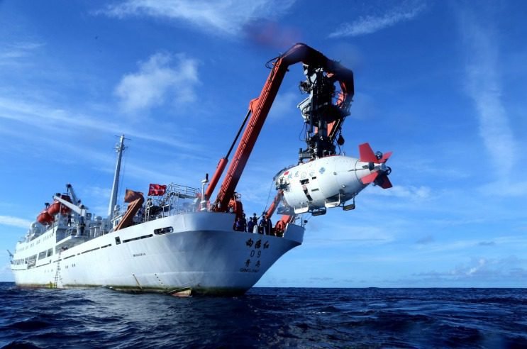
Operating from Chinese ports and institutes such as the Chinese Academy of Sciences (CAS), vessels including missile-tracking ships Yuan Wang 5, 6, and 7, survey ship Xiang Yang Hong 06, low-noise Dong Fang Hong 3, blue-water vessel Shi Yan 6 and submersible support ship Shen Hai Yi Hao — paired with the 7,000-meter-rated Jiaolong submersible — pushed into the Indian Ocean, Bay of Bengal, waters near Guam and chokepoints like the Malacca Strait between 2022 and late 2026.
China pairs parabolic dishes on tracking ships with quieted sonars, bathymetric “lawnmower” grid surveys, and seabed coring on research hulls to gather missile telemetry, map subsea cables and submarine corridors such as the Ninety East Ridge, and assess acoustic propagation and seabed soil strength.
While nominally scientific or commercial, these missions — which have sparked diplomatic friction in Sri Lanka and scrutiny from India and the US — give the People’s Liberation Army Navy (PLAN) peacetime hydrographic, acoustic, and environmental baselines that aid submarine navigation, anti-submarine warfare, and seabed infrastructure without drawing overt military attention.
Establishing peacetime baselines is only the first step, leaving open how China turns civilian-fronted ocean science into gray-zone cable sabotage, anti-submarine warfare, nuclear fleet expansion, and regional power projection.
The dual-use ambiguity of China’s marine surveys complicates countermoves. Writing in an October 2026 report for the Center for Strategic and International Studies (CSIS), Jose Macias III and co-authors observe that China treats state-owned academic research ships as dual-use gray-zone tools under military-civil fusion (MCF), pairing civilian scientific cover and military-trained crews with survey gear to gather hydrographic, bathymetric, and acoustic data.
Macias and co-authors report that these vessels spend a disproportionately large share of time on the high seas near critical subsea cables and chokepoints, preserving plausible deniability and testing ambiguities in the United Nations Convention on the Law of the Sea (UNCLOS) while aiding operational preparation for submarine activity, surveillance, or potential infrastructure disruption.
Examining how survey work links to infrastructure sabotage, Andrew Yeh and co-authors argue in a September 2026 report for the China Strategic Risks Institute (CSRI) that China’s seabed mapping and dual-use deep-sea systems support covert cable cuts around Taiwan, the First Island Chain, and the Pacific to gain asymmetric leverage below the threshold of war.
Yeh and co-authors warn that severing multiple cables during a Taiwan or regional crisis could strain or disrupt US-allied Pacific communications, forcing circuitous rerouting through the Indian Ocean and Atlantic while testing disruption tools, pre-positioning assets, and degrading command, intelligence, and operational coordination.
Taiwan faces especially acute exposure to such disruptions. In a May 2026 report for the Center for a New American Security (CNAS), Jacob Stokes and Ryan Claffey note that Taiwan relies primarily on 15 international undersea cables — and just one or two domestic cables per outlying island — while lacking its own repair vessel and facing slow foreign repairs or near-impossible wartime fixes.
Stokes and Claffey add that China can exploit dense shipping, shallow waters, and gray-zone tactics — including fishing, maritime militia, and coast guard vessels using flags of convenience, Automatic Identification System (AIS) manipulation, or deep-sea cutters — to sever cables with plausible deniability, while satellite backups offer far less bandwidth than subsea fiber.
They also point out that cutting every cable could trigger a communications blackout, though China might leave some links open to transmit cyberattacks and disinformation.
Within the wider US-China undersea contest, the November 2026 US-China Economic and Security Review Commission (USCC) report to Congress states that China’s hydrographic surveys support layered sensing concepts such as “Transparent Ocean” while informing sensor siting, submarine routing, and anti-submarine warfare.
The report adds that although technical hurdles constrain undersea data fusion and sensor persistence, these efforts aim to make waters inside the First Island Chain less permissive and erode US submarine stealth rather than matching US hulls one-for-one, raising operational risk and cost in a Taiwan contingency.
Even as China expands its seabed mapping and sensing reach, US undersea operations across adjacent waters have remained substantial. A June 2026 report by the South China Sea Strategic Situation Probing Initiative (SCSPI), a Chinese think tank, states that in 2025 the US deployed at least one nuclear-powered guided-missile submarine (SSGN) and 11 nuclear-powered attack submarines (SSN) across the Western Pacific — spanning the South China Sea, East China Sea and Java Sea — to signal deterrence.
The scale and reach of China’s survey missions also align with its nuclear submarine buildup. In March 2026 USCC testimony, Rear Admiral Mike Brookes states that China’s 60-plus submarine fleet — comprising six SSNs, at least two SSGNs, six nuclear-powered ballistic missile submarines (SSBNs), and over 50 diesel-electric boats — is shifting from diesel-electric to all-nuclear construction after more than doubling shipyard capacity since 2010 and lifting nuclear output above one hull per year.
Brookes projects roughly 70 submarines by 2027, adding up to six SSGNs, three smaller SSNs, and two SSBNs while retiring older hulls; up to 80 by 2035, roughly half nuclear-powered; and 20 to 30 next-generation SSGNs and SSBNs by the early 2040s, expanding blue-water reach beyond the First Island Chain.
Turning to the Indian Ocean, J. Mohan Malik writes in an August 2026 analysis for the Institute for Security and Development Policy (ISDP) that China’s hydrographic surveys — which Beijing frames around scientific and maritime research — aid submarine operations, anti-submarine warfare, and Beidou-linked seabed sensors along India’s eastern flank and near the Malacca Strait.
Malik adds that these surveys, paired with dual-use ports such as Gwadar in Pakistan and Hambantota in Sri Lanka, signals intelligence (SIGINT) facilities on Myanmar’s Coco Islands, and expanding naval deployments, aim to entrench China as a “resident power” and counter India’s presence in the Andaman and Nicobar Islands.
As China’s expanding hydrographic operations feed undersea surveillance, cable-sabotage options, and nuclear submarine reach across the Indo-Pacific, whether the US and its allies build sufficient seabed awareness, undersea infrastructure resilience and redundancy, and deterrence ahead of a crisis will shape the balance beneath the waves.
Source: Iwpost.com